The following is a very short description of the physical ground at the site of Norstead. It is designed primarily to serve those re-enactors who are participating in Norstead this summer. Much of the physical description is after about two hours walking over the whole area in early April. Any raw information given here is a result of conversations I have had with Cathy Letto, Norstead Coordinator - up to about 25 June. Any impressions or opinions given are entirely my own.
NOTE: I do NOT have any direct connection to the current operation or overall content of the Norstead program. The Viking Trail Tourism Association is ENTIRELY responsible for the design and implementation of this program.
That early date is very important, as the images included here may give people the wrong impressions about both weather and the state of preparation of the site. Obviously, spring had hardly started out in the region when these photos were taken! By July it will be summer, with daytime temps around 20 C. Note as well that construction had hardly started for the season in April. By the time I left St Anthony at the beginning of June, they were starting to apply the sod to the finished roofs, and most of the interior work was well underway.
Sketch Map of Norstead and Area
Check the overall location of the site (lower map). It is almost due west of LAM - about 1 km away in straight line (perhaps a bit further). A VERY important concern - the location is open to the water directly on THREE sides. The North is to Labrador (about 10 miles). The east is open ocean - right to England. The west is open to Quebec some place. Although there is a rock ridge that helps cover the south, the whole area is part way along a peninsula - which means there is open water to the south too.
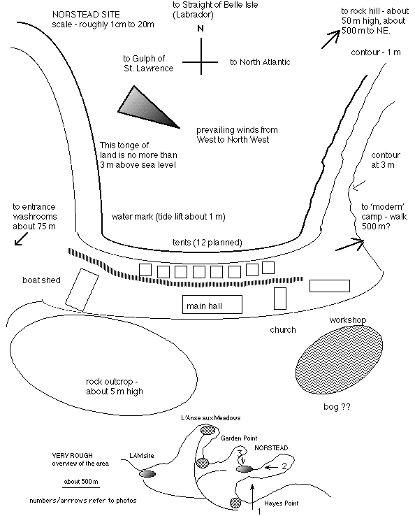
This image is taken from 'Hayes Point', about 1 km to the south of the Norstead site, looking north. L'Anse aux Meadows NHS is off to the left another kilometer or two. You can not see the actual Norstead site here, it is on the opposite side of the narrow spit of land in the middle ground that ends in the pile of rock. The actual spot is just in front of the rock island in the distance. This photo will give you an idea how much cover there is (none) and how open the site is to the water. The "modern camp" is located at the base of the rock pile at the end of the peninsula.
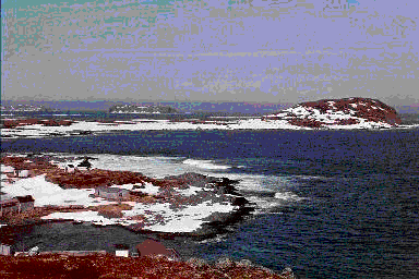
This image is taken from on top of the 'rock pile', looking over the Norstead site, roughly looking west. The rock is a good 500 m above sea level, so this is a panoramic view (and why everything looks so small). you can make out the far shore of Labrador in the far distance. In the middle of the picture is the Norstead site. If you look carefully, you can make out the buildings at the middle on the left side. The "boat shed" can be seen by its framework of rafter beams. This building is a good 30 m long - which gives you an idea how far away I was. As you can see, the Norstead site is at the foot of a very small cove, which will offer cover from the waves. Unfortunately, you can also see how little cover there is from the wind. My personal recommendation to re-enactors is that they consider leather hoods and cloaks. A sheepskin vest might be a great idea. Note that this photo was taken facing into the prevailing wind.
Overall, the site is about 100 - 150 m long and 25 m deep. Water and power will extend only as far as the entry kiosk. Its about 75 from the site proper. Bathrooms and showers will be there too. As of my latest information (late June) these services will be supplied inside a specially designed trailer unit. I was told that there would be a total of 7 flush toilets and four showers (with hot water). Also there is supposed to be a small kitchen area with some modern appliances. Drinking water will be tanked into the site. There is a well planned, but it may prove only safe for wash water.
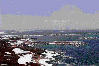
This image is taken from the low spit that forms the western edge of the cove at Norstead. It is more or less looking to the southeast, with the curve of the Norstead site in the foreground. The closest building, seen front on, is the "boat shed". Next are a couple of the sales kiosks - which will NOT be positioned at this spot for the opening. (Here being used as construction shacks.) Next is the long line of the "chieftains hall". The small building with the roof just about finished is the "stave church". Last on the left is the "workshop".
Where the tents were originally planned to go is right up against the storm line. This has now been changed (as of late June) to have the tents placed in the open area between the "boat shed" and the "main hall". The ground here is broken rock scree with about 3-4 c of moss on top - largely ripped up by the heavy machinery at the point these photos were taken. They are planning a board walk (shown) and to overlay the entire Norstead site with grass sod. Again, as of late June the plan is to have a gravel path run into the site as well - allowing for possible vehicle assess (for unloading after hours only.)
As is mentioned above, the position of the tents used by the re-enactors has been changed from along the shore line to the empty space at the base of the low cliff. This is elevated ground (well, say about 3 m above sea level). The rock face is about 5 m higher - and should provide a wind break from the south. Also it may mean that the positioning of the individual tents may be more like a real camp - rather than the artificial straight line originally proposed by the architect (!).
A very important factor for those re-enactors considering using the "modern camp" area. It is TOTALLY man pack. About another 500 m past the east end of the site - hard to say exactly were (they had nothing laid out yet in April). The area is a huge dead flat plain, elevated up to - 5 m above sea level with NO cover at all. Thin moss over broken rock (ie - not flat for tents - heavy steel pegs required, air mattresses or camp cots a real good idea.) The parking lot is very large, and made of crushed stone. As well the entry road is wide, flat and of good quality. The parking area is about 500 off the main paved road into the area.
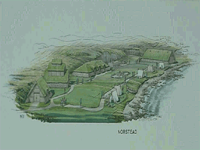
This is the 'original artist's concept' drawing released by the VTTA (taken from their web site) of the finished Norstead site. The view is from the East, looking back along the beach. (This image has been compressed along the horizontal.)